Mount Batur Volcano in Indonesia Bali

There are various natural formation in Batur Volcano region which are very beautiful and important as the scientific evidence of the process formation of the Batur volcano including its caldera. The natural formation is necessary to understand and conserved in the interest of tourism, education and research.
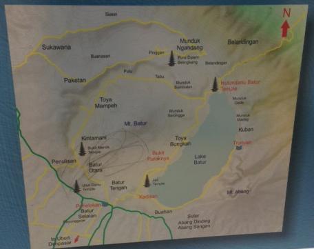
Batur Volcano is an active volcano which is located in the district of Kintamani, Bangli District, Bali Province. The first caldera wide of Batur Volcano is 13.9 X 10 km². The second caldera wide of Batur Volcano is 7 km².
Geology of Batuk Caldera
Batur Caldera Geopark lies within active volcanic area of Batur Volcano. At wide region of 366.4km², the Geopark area covers the entire of Kintamani District area consisted of 72 villages and it subdivided into 322 banjars. Beside the government banjars, there are 159 pekraman which are traditional autonomous units. It has impressive geodiversity , biodiversity and culture- diversity comparing to others volcanos in Indonesia. Establishing Bali as the main tourist destination in Indonesia may provide access in supporting Bangli Regency as the Batur Caldera Geopark area so that it become a place of extremely high scientific, educational, cultural and tourism values of internation importance, which will be increasing people participation and local economic incomes.
As regard land use system, it is important to point out that 44% dan 21.32% of the surface area of the proposed Geopark are orchard and unirrigated agriculture. Forest and to shrub and pasture are covered area within 7.55%,14.29%, and 2.12%, respectively. Bare land areas cover 5.55% of the surface area and lake account for 4.47%. The remaining 0.66% is urban land occupied by settlement. Bangli’s geographical conditions support agricultural activities. These are aimed at being self-Sufficient in food production in accordance with its population growth.
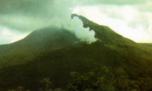
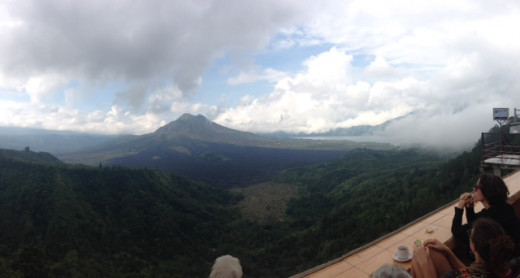
Batur Caldera is a placed blessed with beauty. A good angle-view through Panelokan, a view-point in southern caldera rim, displays a fantastic bunch of certain phenomena, such as caldera rim of Caldera-I and Caldera-II,Batur volcanic edities, volcanic products, and lake. Batur Volcano emerged in a large bowl of Batur Caldera is presiding over it all, adds regal repose and power when it is erupting. The land rumples like black spurs of lava, expanse interspersed by green trees. A bluish water of Lake Batur is one of the finest volcanic landscape in the world (Can Benmelen, 1949). From this landscape it might be eligible for explaining natural phenomena as educational matter by displaying some panels.
Location of Mount Batur

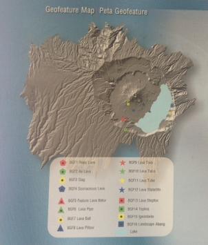
Geo Site Map
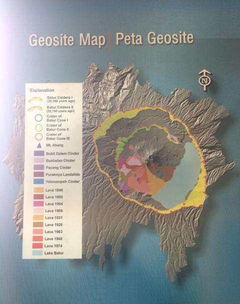
Batur is a “Window of the earth” displaying a formation of double-Calderas(cadera-I and Caldera II) in a lapse of thousands years time influenced by the dynamic process of magmatism. Comparing to other volcano caldera system in Indonesia, which is mostly influenced by caldera-collapse and combination of tectorics and caldera collapse system, the formation of Batur Caldera complex was totally destructed by violent explosion generating voluminous ignimbrite (flowage material produced by a violent eruption of volcano).Mostly Bali island is covered by ignimbrite deposit generated by these processes at 29,000 and 20,150 years ago generating Caldera-I and Caldera-II, respectively. It has revealed a rich and varied geographical heritage. National and International researches have been conducted and published through journal and academic output.
The rim of Caldera I is elliptical-shaped with size 13.8km X10km and trending to NW-SE, whereas the second caldera rim formed a circular depression that has 7km in diameter. The southeastern part of inner caldera is already cobered by the Batur Lake which has a crescent –shaped with maximum length 7km and width 1.5km. Post caldera volcanism was marked by the formation of Batur Volcano emerged in the caldera rim consisting of three volcanic cones, Batur- 1(+1,717m), Batur-II(+1,589m) , and Batur-III (+1,410m) that formed a NE-SW lineament. Among such events, the phreatic and phreatomagmatic eruption, generated by interaction between magma and ground water, formed more than ten maars and cinder cones, scattered on the caldera floor, but some of them were buried by Batur eruptive producrs, mainly phreatomagmatic deposit. Some crater remnants and cones can be recognized, although they ate not perfectly circular.
Eruption History
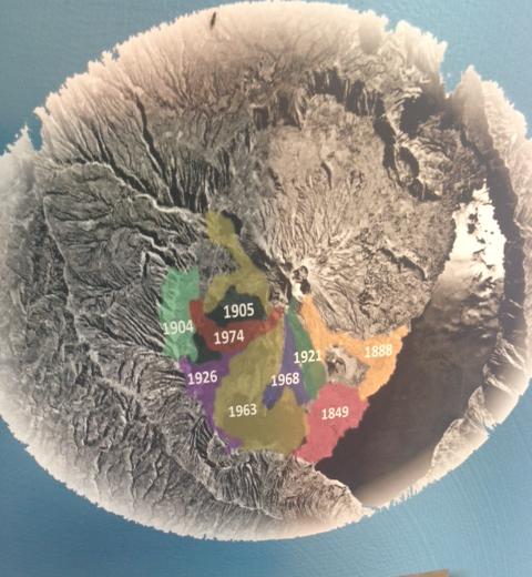
The resent activity of batur Volcano, generated at least 22 eruptions since 1800, generally strombolian in nature and producing lava flow of basalt and basaltic andesite. Historic lava flows erupted in 1849, 1888, 1904, 1905, 1921, 1926, 1968, and 1974. The activity of Batur volcano in historical times was highlighted by the violent eruption of 1963. The eruption occurred in 1994 and continued until the end of 1999, and the latest was in 2000.
Did you feel like going to Mount Batur Volcano?
Biodiversity of Mount Batur
Volcanic eruptions can bring devastation, but they can also bring renewal. Eruptions clear out old, dead plants. While the ash helps plants grow back more quickly, and stronger than before.
Volcanic ash makes a great fertilizer to help plants grow. Farmers near volcano take advantage of this by growing their crops. Without volcanoes, people in some of the poorest places in the world would not have enough to eat .Without the ash, the land would not be fertile enough to feed everyone.
In local philosophy, Batur Caldera is believed possessing four main components of the earth, i.e. land, water, fire, and air, as the spiritual aspects of nature. They worship the natural world and they believe themselves as an inextricable part of it. They are participants within the web of life, not caretakers living outside. The spirits that inhabited forest, volcano, and lake could be magnanimous or malevolent, depending on circumstances.
For the worship natural world, the Balinese Hindu builds temple as adaptation and presentation of mountain-like figure. It is designed as an open air worship place within enclosed walls, connected with series of intricately decorated gates to reach its compounds. 27 Pura are found around Batur Caldera. The temple buildings made from carved stone of andesitic-basaltic lava that produced by the Batur Volcano. Some of Pura are categorized as archaeological site. Contrary to elsewhere in Hindu Bali, the Trunyanese fo not cremate their dead. Instead, after a ritual cleansing with rain water, the body of the deceased in placed in a bamboo cage under the taru menyan tree until the forces of nature, in particular wind, has dissolved the body tissues and only the skeleton remains.
")


